
The proposal: a fully automated maglev high-speed rail network stitching together the top 100 US cities and 503 commercial airports — built in five years, with fares capped between $5 and $50. This is what it would take, what it would cost, and whether it could actually happen.
The HSR-26 proposal imagines the United States divided into 75 civil infrastructure sectors, all building simultaneously — elevated maglev viaducts and subterranean tunnels going up in parallel instead of in sequence. Superconducting magnetic assemblies lift the trains off the rails entirely: no friction, no wheels, speeds that make short-haul flights pointless. The 15 Super-Mega Ports feed the build directly, pumping 120 million metric tons of steel onto finished track sections to accelerate the inner trunks.
All six trunks from the HSR-26 proposal, drawn as one interoperable maglev grid — in the proposal's own "no sharp corners" curving style. Hover or tap any colored line.
Proposal network. Corridors and stops are exactly as named in the HSR-26 proposal documents — a vision map, not an engineering survey. Positions are approximate; only the Northeast Corridor and Brightline Florida segments overlap real operating rail.
Every corridor below is named in the proposal documents. Together they form a single interoperable maglev grid.
The spine it all hangs on: Boston–New York–Philadelphia–Washington, the densest travel market in the country. This is where maglev proves itself first — replacing the congested Acela corridor and the I-95 parking lot with 300+ mph service. The proposal routes construction crews and materials for the coastal defense mega-projects (BOS-1, NYC-2, LIS-3) along this same trunk.
Washington down through Raleigh, Charlotte, and Atlanta to Jacksonville, Orlando, and Miami — the Atlantic seaboard's missing link. It ties the Southeast's booming metros into the national grid and feeds the Florida mega-projects (MIA-9, TPA-14, JAX-10), including the planned Straits of Florida terminus at the Miami offshore port.
Dallas–Houston–San Antonio (with Austin on the loop): the Texas Triangle is already one of the world's great mega-regions, and the proposal treats it as a self-contained high-frequency maglev circuit. It also serves as the logistics backbone for the Gulf Coast mega-projects — GAL-12, SAB-16, CRP-18 — moving structural alloys straight from interior stockpiles to deepwater gates.
Seattle–Portland–San Francisco–Los Angeles–San Diego: the Pacific corridor, running the full length of the coast the proposal is trying to defend (SFO-20, AST-21, SEA-22). This is the trunk that would finally do what California's conventional high-speed rail has struggled to deliver — true 300+ mph service, with the 260,000-strong Golden Gate barrier workforce riding it daily.
Chicago as the beating heart: spokes radiating to Minneapolis, Detroit, St. Louis, Kansas City, and onward. The proposal leans on this hub to deploy 140,000 tradespeople across the Great Lakes Control Grid (GLC-25) and to pump Midwestern agricultural cargo from the Mississippi Delta Super-Hub straight onto global trade lines.
The long bridges that make it a national network: New York–Chicago–Denver–Salt Lake City–San Francisco across the north, Los Angeles–Phoenix–Dallas–Atlanta–Washington across the south, and Chicago–Dallas–New Orleans tying the interior together. These are the hardest miles — mountains, deserts, and thin demand — but they're what turn regional systems into one country-spanning grid.
Phase 1 wires the United States. Phase 2 takes the same grid international — north to the four most populous metros in Canada, and south down the spine of Mexico, all the way to Mexico City.
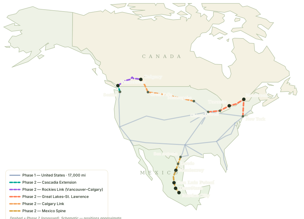
Phase 2 schematic — dashed lines are the proposed international extensions. Positions approximate; this is a vision map, not an engineering survey.
Seattle–Vancouver: the shortest new miles in Phase 2 and the easiest border on the map. The West Coast Spine simply keeps going north, joining the Pacific Northwest's two great port cities — 140 miles apart with no fast way between them today. Vancouver's metro holds 3.1 million people, and the corridor already has a name, a studied route, and a century of cross-border habit behind it.
Chicago–Detroit–Windsor–Toronto–Kingston–Montreal, with a second Montreal feed from New York via Albany. This rides Canada's own number-one rail axis — the Quebec City–Windsor corridor — and plugs it into the Midwest Hub. Toronto (7.1 million) would be one of the largest metros on the entire grid; Montreal (4.6 million) gets two ways in, from Chicago and from New York.
Minneapolis–Great Falls–Lethbridge–Calgary: the northern-tier alignment, crossing the plains the way the Empire Builder still does. Calgary (1.8 million) is Canada's fourth-largest metro and its energy capital. These are the longest, emptiest miles in Phase 2 — and paired with the Rockies Link (Trunk 11), they give Calgary two ways in: east across the plains from Minneapolis, and west through the mountains from Vancouver.
San Antonio–Laredo–Monterrey–San Luis Potosí–Querétaro–Mexico City, straight off the Texas Star Triangle. It stops at Monterrey (5.3 million, Mexico's industrial capital) and Querétaro — where Mexico is already building real passenger rail toward the capital today — and terminates in Mexico City, whose 22.3-million-person metro area is the largest in North America. At Phase 1 speeds the whole run is about three hours.
Vancouver–Kamloops–Revelstoke–Banff–Calgary: the line that joins Canada's two western metros, following the Canadian Pacific's historic mountain alignment through Rogers Pass and Kicking Horse Pass. At Phase 1 speeds it is about a two-hour run; today the same trip is a ten-hour drive through the mountains. It makes Calgary a true junction — the Pacific one way, the prairies and Chicago the other — and Canada's west one system instead of two stubs. The honest price: this is the most expensive segment in Phase 2, hundreds of miles of avalanche country and some of the longest tunnels on the continent.
Canadian metro populations: Statistics Canada estimates, July 2025. Mexican metro populations: 2020 census. Every Phase 2 stop is queued for the same per-stop atlas treatment as the 287 Phase 1 stops — cost breakdown, proposed terminal site, city facts, and before/after aerial mock-ups.
Figures are from the HSR-26 proposal (Report 26 of the 30 Mega-Projects series). For scale: $8.5 trillion is roughly a third of current US annual GDP, deployed over five years.
The honest answer is: the engineering is the easy part. China built roughly 50,000 km of high-speed rail in under two decades, which proves that a determined state can lay track at continental scale. Maglev itself works — the physics are settled and the Shanghai line has run safely for 20 years.
The hard parts are cost and governance. California's experience suggests American high-speed rail costs 3–5× what comparable projects cost abroad, driven by land acquisition, litigation, and fragmented authority. And no country has ever attempted maglev at even 1% of this scale — 17,000 miles of superconducting guideway is an extrapolation, not a precedent.
The five-year timeline is the least believable element: it requires 75 sectors building in perfect parallel, 1.8 million workers materializing on schedule, and a legal regime that simply doesn't exist in the United States. A phased 20–30 year build of the densest corridors first — the approach every successful rail nation actually used — is the version of this vision with real precedent behind it.
Verdict: technically feasible, financially staggering, politically the hardest infrastructure project in American history. Start with the Northeast Corridor and the Texas Triangle; prove the model; then go continental.
"A sprawling, highly organized spiderweb of elevated viaducts and ground-level tracks curving organically through the American landscape, completely bypassing 90-degree angles and sharp corners."
— HSR-26 aerial mock-up description, Foreign Labor & Deployment appendixThe proposal's design standard calls for "Non-Euclidean Urban Design" — no sharp corners anywhere in the network, with tracks flowing in continuous curves. Year 1 is the 75-front mobilization; years 2–3 lay track and bore tunnels around protected lands; year 4 injects port aggregates to accelerate the inner trunks; year 5 is electrification and launch under the $5–$50 fare cap.