
Raleigh, NC
Stop on the proposed 17,000-mile maglev network. Next stop: Cary, NC (8.1 mi).
About Raleigh
Raleigh is the capital city of the U.S. state of North Carolina. It is the second-most populous city in the state, tenth most populous city in the Southeast, the largest city in the Research Triangle area, and the 39th-most populous city in the U.S. Known as the "City of Oaks" for its oak-lined streets, Raleigh covers 148.54 square miles (384.7 km2) and had a population of 467,665 at the 2020 census.
Source: Wikipedia summary (full article). Population and facts as published there.
Cost breakdown (proposal-scale estimates — see math)
| Item | Basis | Estimate |
|---|---|---|
| Terminal construction | Large city — metro tier (range $2–4B) | $3B |
| Land acquisition | Regional factor 1.5× on $200M base | $300M |
| Track: Raleigh → Cary | 8.1 mi × $500M/mi | $4B |
| Annual operations (share) | Staffing, power, maintenance | $60M/yr |
| Stop total (excl. annual ops) | $7.3B |
Best terminal location (proposed)
The Union Station district in the Warehouse District. Raleigh Union Station already anchors Amtrak and regional transit downtown, and the surrounding Warehouse District has the redevelopment-ready blocks a maglev terminal would need. The site serves the state capital's government and university workforce and sits on the natural Triangle corridor toward Cary.
Before / after
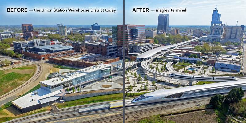
Aerial mock-up (illustrative, not an engineering rendering). Left: the proposed site today. Right: with the maglev terminal.
- West Raleigh (NC State area) — university district on the corridor.
- The PNC Arena district — event venue complex west of downtown Raleigh.
- Crossroads (Cary) — established mixed-use node on I-440.